One of the most significant advancements from the Elios 2 to the Elios 3 is the integration of a LiDAR sensor, which allows for the creation of detailed 3D maps. This new feature has transformed how inspections are conducted in confined and challenging environments.
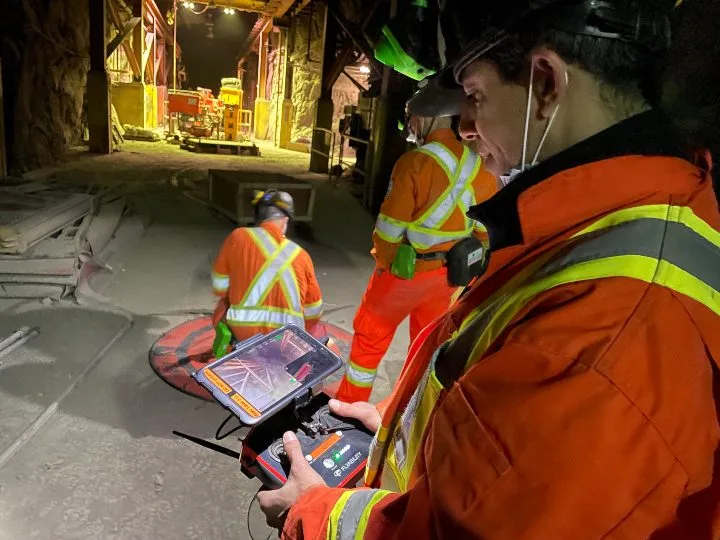
The Elios 3 collects LiDAR data in real time as it flies through an asset, generating a 3D Live Map that appears on the operator’s tablet. This map not only helps during the flight but also enables the creation of survey-grade 3D models after the mission using GeoSLAM software. The image below shows the 3D Live Map in the lower right corner of the screen.
Since its launch, the Elios 3 has received positive feedback from inspectors worldwide who say the 3D mapping capability is changing the way they work. These 3D maps help them:
- Visualize defects with high precision.
- Navigate dusty or low-visibility environments.
- Measure stockpiles faster, safer, and more accurately.
- Ensure full coverage when inspecting large, uniform spaces like tanks and boilers.
While many have embraced this technology, some users are still learning how to best apply 3D mapping in the field. To provide practical examples, here are six real-world use cases where the Elios 3's 3D mapping has made a difference.
**1. Helping Decommission an Old Power Plant**
Industry: Power Generation
At a decommissioned power plant owned by Vattenfall, the Elios 3 was used to create 3D models of areas that were too dangerous for human entry. The drone provided accurate real-time and post-flight 3D maps, helping engineers better understand the site.
[Watch the video](#) | [Read the full case study](#)
**2. Finding the Cause of an Ore Pass Hangup**
Industry: Mining
A mining operation used the Elios 3 to quickly locate a clog in an ore pass in just ten minutes. Traditional methods had taken two months of drilling, but the 3D mapping feature allowed the team to pinpoint the exact location and visualize the issue clearly.
[Watch the video](#) | [Read the full case study](#)
**3. Improving Efficiency in Stockpile Measurement at a Cement Plant Silo**
Industry: Cement
A French cement plant used the Elios 3 to measure clinker stockpiles safely and accurately. Despite poor visibility due to dust, the LiDAR data enabled precise measurements in under 30 minutes.
[Watch the video](#) | [Read the full case study](#)
**4. Mapping Unknown Areas of an Old Mine**
Industry: Mining
Luxembourg’s Mines Division used the Elios 3 to map an old slate quarry being converted into a museum. The drone’s LiDAR made it possible to create detailed 3D maps of hard-to-reach areas quickly and efficiently.
[Watch the video](#) | [Read the full case study](#)
**5. Planning, Tracking Changes, and Geolocating Defects in Water Tanks**
Industry: Water/Wastewater Infrastructure
Lausanne’s Water Department used the Elios 3 to track changes over time and geolocate defects in water tanks. The 3D maps allowed for safe and efficient future inspections without requiring personnel to enter confined spaces.
[Watch the video](#) | [Read the full case study](#)
**6. Improving Safety and Accuracy for Stockpile Measurements at a Salt Mine**
Industry: Mining
At a German salt mine, the Elios 3 replaced manual, dangerous methods of measuring stockpiles. By collecting data from the ground, the drone improved both safety and accuracy in volume calculations.
[Watch the video](#) | [Read the full case study](#)
If you're interested in seeing the Elios 3 in action, [watch a demo now](#).
CNC Machine Tools,CNC Lathe,CNC Machining Machine Tool,CNC Pipe Thread Lathe
HENAN MAJOR INDUSTRIES IMP. & EXP. CO., LTD. , https://www.henanminingcrane.com