One of the most significant upgrades from the Elios 2 to the Elios 3 is the integration of a LiDAR sensor, which allows for the creation of detailed 3D maps. This feature has completely transformed how inspections are conducted in confined and hazardous spaces.
The LiDAR data collected by the Elios 3 generates a real-time 3D Live Map as the drone navigates through an asset. This map is displayed on a tablet, helping operators understand the environment as they fly. After the mission, the data can be processed using GeoSLAM software to create high-precision 3D models, offering valuable insights for further analysis.
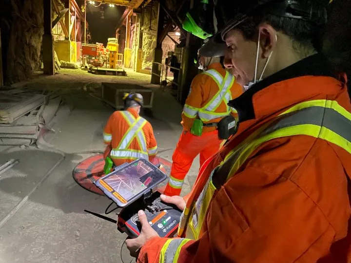
The 3D Live Map is visible in the lower right-hand corner of the tablet, making it easy for users to monitor their progress during flights.
Since the launch of the Elios 3, we've received positive feedback from inspectors around the world who say this new 3D mapping capability is changing the way they work. The 3D maps allow them to:
- Accurately locate defects within structures.
- Operate in dusty environments where visual feeds are limited.
- Perform stockpile measurements faster, cheaper, and more safely.
- Ensure complete coverage when inspecting uniform spaces like tanks and boilers.
While many have embraced this technology, some inspectors are still exploring how to best use 3D mapping in the field. To help make it more tangible, here are six real-world examples of how the Elios 3’s 3D mapping is being used in confined spaces.
**1. Helping Decommission an Old Power Plant**
Industry: Power Generation
A decommissioned power plant owned by Vattenfall used the Elios 3 to create 3D models inside a "no-go" zone, improving understanding of areas that are unsafe for humans. The drone produced accurate 3D maps both in real time and after processing with GeoSLAM software.
[Watch the video](#)
*Read the full case study.*
**2. Finding the Cause of an Ore Pass Hangup**
Industry: Mining
A mining operation used the Elios 3 to quickly identify the cause of a clog in an ore pass, pinpointing its exact location in just ten minutes. This saved time and resources compared to traditional methods.
[Watch the video](#)
*Read the full case study.*
**3. Improving Efficiency in Stockpile Measurement at a Cement Plant Silo**
Industry: Cement
A major cement plant in France used the Elios 3 to measure clinker stockpiles efficiently. Despite heavy dust, the 3D Live Map allowed the drone to collect all necessary data in 30 minutes.
[Watch the video](#)
*Read the full case study.*
**4. Mapping Unknown Areas of an Old Mine**
Industry: Mining
Luxembourg's Mines Division used the Elios 3 to map an old slate quarry turned into a museum. The LiDAR sensor made it possible to create detailed 3D maps quickly and accurately.
[Watch the video](#)
*Read the full case study.*
**5. Planning, Tracking Changes, and Geolocating Defects in Water Tanks**
Industry: Water/Wastewater Infrastructure
Lausanne’s Water Department used the Elios 3 to create precise 3D maps of water tanks, enabling long-term monitoring and safer inspections.
[Watch the video](#)
*Read the full case study.*
**6. Improving Safety and Accuracy for Stockpile Measurements at a Salt Mine**
Industry: Mining
At a salt mine in Germany, the Elios 3 helped engineers calculate stockpile volumes without requiring workers to climb dangerous structures, significantly improving safety and accuracy.
[Watch the video](#)
*Read the full case study.*
If you're interested in seeing the Elios 3 in action, **watch a demo now** and discover how 3D mapping is transforming industrial inspections.
Industrial Crane
Industrial crane is a heavy-duty machine used to lift and move heavy loads in industrial settings such as construction sites, factories, steel mills, and ports, etc . It consists of a large, sturdy steel frame that supports a boom or arm that can be extended and retracted to reach different heights and distances. The boom is typically equipped with a hoist or winch that can lift and lower loads, and the crane may also be equipped with various attachments such as hooks, buckets, or magnets to handle different types of materials. Industrial cranes can be powered by electricity, diesel fuel, or hydraulic systems, and they come in a wide range of sizes and configurations to suit different applications and environments.
Industrial crane have many different types as per application location, such as Overhead Crane, Gantry Crane , suspension crane, Jib Crane , Semi Gantry Crane, etc. These types cranes with different lifting tools, such as hooks, Container Spreader, electric magnet plate, kinds of grab, etc, work together with different types of cranes to lift different goods and move planed location.
Also, There are several methods for controlling a crane, including:
1. Manual control: This involves a crane operator using hand levers, foot pedals, or joysticks to control the crane's movements. The operator must have a clear view of the crane and the load being lifted.
2. Radio control: This method involves using a remote control to operate the crane from a distance. The operator can stand at a safe distance and control the crane's movements using a handheld device.
3. Computer intelligent control: This method involves using a computer to control the crane's movements. The operator inputs the desired movements into a computer program, which then controls the crane's movements automatically.
4. Automated control: This method involves using sensors and cameras to automate the crane's movements. The crane can be programmed to move and lift loads without the need for a human operator
As per theirs structure, there are overhead crane, bridge crane, gantry crane, semi gantry crane, port cranes, etc.
Industrial Crane,Bulk Coal Loading Crane,Mass Goods Loading Crane,Chain Bucket Materials Crane
HENAN MAJOR INDUSTRIES IMP. & EXP. CO., LTD. , https://www.henanminingcrane.com